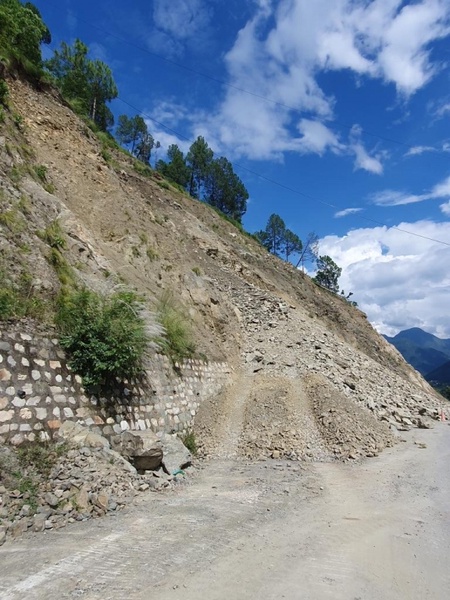
Images of landslides devastating communities, destroying homes and infrastructure and claiming lives have become a more familiar sight as the impacts of climate change are felt around the world.
New research led by the University of Aberdeen (UK) is aiming to improve understanding of the risks of landslides and to mitigate the impact – felt across generations - on those caught in their muddy wake.
The project, which will see experts from the University collaborate with counterparts in India to focus on the Central Himalayan region, has been awarded combined funding of more than £1million.
The UK researchers are supported by a grant from the Natural Environment Research Council (NERC), part of UK Research and Innovation, and specialists in India are funded by the Ministry of Earth Sciences, India (MoES).
Rapid population growth and infrastructure development in the Indian Himalayan states – together with the increasing frequency of extreme precipitation events and the presence of glacial lakes – has increased the region’s vulnerability to landslides.
Three-quarters of annual rain in the Himalayas arrives in the monsoon season from June to September. Within this rainy period are sudden and extremely intense cloudbursts, often concentrated on small areas.
Precipitation-triggered landslides are already happening extensively across the Himalayas and are predicted to get worse.
When a huge flank of a Himalayan mountain close to the study area failed and fell into the valley below in 2021, it was described as hitting the valley floor ‘like 15 atomic bombs’.
The cascade of debris claimed more than 200 lives and destroyed hydro-electric infrastructure worth hundreds of millions of dollars.
More recently, 41 Indian mine workers spent 17 days trapped underground following a tunnel collapse in the study area in Uttarakhand state in November, further underlining the need for greater understanding of ground stability and risks in these areas.
The project will bring together geoscientists, experts in remote sensing and geotechnical analysis, social scientists and community engagement specialists to conduct mapping, monitoring, reconstruction, and analysis of landslides using satellite, drone, geotechnical, and tree-ring data.
The team will also investigate community perceptions of hazards and develop socially acceptable mitigation guidelines.
Participating scientists from The University of Aberdeen and India (from Birbal Sahni Institute of Paleosciences, Borehole Geophysics Research Laboratory, Jawaharlal Nehru University, GB Pant National Institute of Himalayan Environment, and University of Jammu) have previously led pilot studies on landslides and cascading glacial hazards. The new funding will enable the integration of various datasets and perspectives to develop robust methods to assess landslide risks in high-mountain regions and to mitigate the impacts on communities.
Project Lead Dr Anshuman Bhardwaj, senior lecturer in Geosciences at the University of Aberdeen, said: “Geohazards such as landslides cause extensive damage to essential infrastructure and local economies, leading to mass displacements. Understanding of these processes and their long-term impacts needs substantial research.
“Our project will fill existing gaps in untangling the nexus between hazards, humans and infrastructure and aims to develop effective methods for monitoring and mitigating landslides in high mountains such as the Himalaya. By providing accurate hazard assessments, risk analyses, and community-based mitigation guidelines, our research will enhance resilience to geohazards and facilitate preparedness and increased awareness in high-mountain communities.
“Considering that the UK is also facing increasing coastal erosion and landslides, the easily adaptable methodological framework of this project can be useful to implement locally.”
The research will provide improved understanding of the relationship between slope failure mechanisms and slope materials, analyse and reconstruct past landslide events using tree-ring records, and model potentially destructive future glacial landslide events.
The ground-breaking project integrates multiple disciplines to cover all aspects of landslides in a high-mountain catchment and will serve as a benchmark for similar research in other landslide-prone high-mountain regions, contributing to effective monitoring and mitigation of geohazards.
Project Co-Lead Dr Lydia Sam, lecturer in Geosciences at the University of Aberdeen, added: “There is a lack of comprehensive hazard assessment models that consider both, the environmental as well as social aspects and our project is a much-needed step in that direction.”
Indian Project Lead Dr S. Nawaz Ali explained: “The project will inform policymakers about landslide-prone regions, ensuring sustainable development of critical infrastructure. Mitigation strategies, such as identifying optimal shelter locations, alternative routes for food supply, trade and migration routes, slope stabilisation strategies, drainage and vegetation management, and adaptable land use planning will enhance resilience to geohazards.”


