Dr. David Cornwell, Senior Lecturer of Geophysics, explains the circumstances leading to the devastating earthquakes currently affecting Turkey and Syria.
The ongoing devastation in south-eastern Turkey and Syria, significant loss of life, and infrastructural damage has been at the forefront of news agencies across the world.
As I write this, there are numerous reports of people being unaccounted for, and precious few reports of people being pulled from the rubble.
Countries across the world have sent specialist teams to search for and treat survivors, plus monetary and other aid to support those affected by the damaging earthquakes, but it is a race against time to free those still trapped who are waiting for help.
There is both an immediate and long term need for aid for the people affected by this natural disaster so please donate if you are able to. Some links to do so are available at the bottom of this article, along with links to maps and technical data that were referred to in the course of writing.

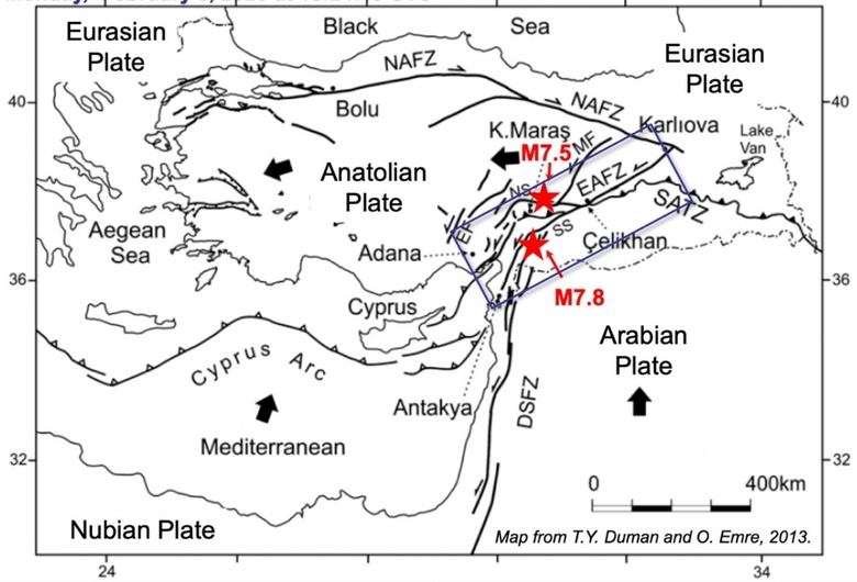
IMAGE: On this tectonic map, NAFZ is the North Anatolian Fault Zone and EAFZ is the main trace of the East Anatolian Fault Zone. The locations of the M7.8 and M7.5 earthquakes are shown by the red stars. Notice how the East Anatolian Fault Zone has multiple strands in the region. Image courtesy of the U.S. Geological Survey.
An initial M7.8 strike-slip mainshock at a depth of 17.9 km (11 miles) occurred at 4:17 a.m. local time near the town of Nurdağı in Turkey’s Gaziantep province followed by a M6.7 and many other aftershocks. Then, after 9 hours, a M7.5 strike-slip earthquake occurred to the north at 10 km (6 miles) depth, followed by many more aftershocks.
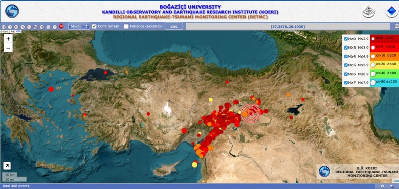
In the 48 hours since the mainshock, over 400 earthquakes with M>2.5 were recorded along two principal fault directions: NE-SW following the East Anatolian Fault and E-W following its subsidiary Sürgü Fault.
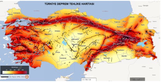
IMAGE: On this earthquake hazard map, red areas show regions of Türkiye that are most likely to experience high peak ground acceleration from the occurrence of large earthquakes. Black lines show the surface locations of major faults.
This part of Turkey is classified as a high earthquake hazard zone, owing to the ~500-km (~300 mile) long East Anatolian Fault, which accommodates the northwards ‘push’ of the Arabian tectonic plate at ~11 mm (about half an inch) per year that, in turn, squeezes the Anatolian plate, which Turkey sits on, westwards. However, the East Anatolian Fault has been relatively dormant in recent times, with three major fault ruptures and M7+ earthquakes last occurring during 1795-1893.
The magnitude and intensity associated with the two largest earthquakes was surprising, and with their shallow depth, shaking with acceleration of up to 2G (twice gravity) has been reported at some seismometer stations. It is estimated that a few metres (~10 feet) of slip may have occurred along a few hundred kilometres (1-2 hundred miles) but better fault models will most likely be available from the scientific community soon.
Strong shaking occurred over a region of more than 150 square kilometres (~58 sq. miles) and many buildings have collapsed or been significantly damaged, with some infrastructure such as gas pipelines ablaze. Landslides, a minor tsunami wave in the Mediterranean Sea, and isolated ground liquefaction have also been reported.
IMAGE: This screenshot of an interactive seismicity map of Turkey shows the location of all magnitude earthquakes that have been recorded by the Turkey national seismometer network since the M7.8 earthquake. Red and yellow colours are shallower and deeper earthquakes, respectively.
The numerous recorded aftershocks show the Earth’s readjustment from these major earthquakes.
These will likely reduce in magnitude and occurrence over time; stresses gradually re-equilibrating as the earthquake cycle enters its post-seismic phase, which will likely continue for tens of years. Survivors of this disaster will also enter a different phase, with recovery and rebuilding likely to take significant time and require substantial support.
The University has communicated to staff and students who hail from Turkey and Syria on the availability of support services, and we would encourage any other staff and students who may be affected to get in touch, either via staff support or student support
Links to donate
- Oxfam Turkey And Syria Earthquake Appeal
- British Red Cross Turkey And Syria Earthquake Appeal
- Actionaid Turkey And Syria Earthquake Appeal
- Christian Aid Turkey And Syria Earthquake Appeal
- Islamic Relief Turkey And Syria Earthquake Appeal
Maps and technical data on the earthquakes
- Kandilli Observatory And Earthquake Research Institute (KOERI) Regional Earthquake-tsunami Monitoring Center (RETMC) interactive map
- The USGS Earthquake Hazards Program Turkey M 7.8 earthquake page
- The USGS Earthquake Hazards Program Turkey M 7.5 earthquake page
- Seismological Facility for the Advancement of Geoscience - 7.8 Turkey earthquake information page
- European-Mediterranean Seismological Centre (EMSC) Turkey Earthquake page
- M 7.8 in Turkey/Syria Earthquake Report page - Jay Patton online

