|
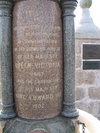
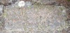
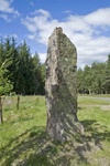
A squarish block of reddish granite, about 4'7" in maximum height and 7' in girth, which was dug up many years before 1842 and was erected on top of the hill of Corsedardar, in the belief that it had marked the grave of some eminent person. The stone has been split, and now has the two portions set into a bed of concrete and pieced together by strong iron bands. Tradition says that it marks the spot where Dardanus, a Pictish king, was killed. A stone, 1.5m high, 0.8m wide, and 0.2m thick, generally as described, and possibly a cist slab. Visited by OS (R L) 12 June 1972. from RCAHMS
More Information
|
|
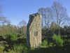
Remains of cairn; a curving scarp in the E probably represents the edge of the cairn in this quadrant; otherwise all that can be seen is turf-covered debris, insufficient to estimate the size and shape of the cairn. Part of it was dug into in c1860 when human remains and several silver coins were found.
More Information
|
|
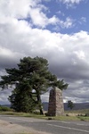
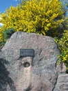
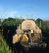
A modern stone menhir with bronze plaque commemorating a 14th century battle.
More Information
|
|
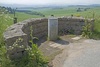
Souterrains are a type of iron-age architecture that seems to have been fairly common in the area that is now Aberdeenshire, the most common assumption is that they were used for storage of grain and other food-stuffs. Souterrain curved and lined with dry stone walls (the walls have been mortared in modern times) and heavy roof slabs. Accessible but the visitor will require a torch to explore the few metres of passageway inside.
Various authorities report 1 or 2 possible cupmarks on left wall (cupmarks are usually thought to have been created in earlier periods, their occurrence in iron age and later artefacts could be taken as an indication of some special respect for these older interventions).
The 19th century excavation finds were reported by A Jervise 1865, as the floor being littered with ashes, 2 querns, some unglazed pottery shards, cattle bones and a large bead.
More Information
|