The geology of the Rhynie area was originally mapped and described by Geikie in 1878 with further work by Wilson and Hinxman (1890) and Read (1923). The most recently revised map was published in 1993: BGS Sheet 76W. However, it has only been in recent years following the drilling programmes undertaken by the University of Aberdeen that the geology and particularly the sedimentary succession or lithostratigraphy is better constrained (Rice et al. 2002).
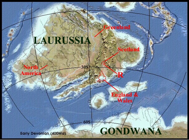
The sediments which host the Rhynie chert, as mentioned in previous pages, are Early Devonian (Pragian) in age and form a small part of what is commonly known as the Old Red Sandstone or ORS. The ORS comprises a sequence of continental sediments deposited by streams, rivers and lakes throughout the Devonian Period when Scotland, much of northern Europe, Greenland and North America formed a large continent called Laurussia or the 'Old Red Continent', located between 0o and 30o south of the equator. During the Early Devonian (Pragian) the Rhynie area was situated in the subtropics around 28o south of the equator (see inset below).

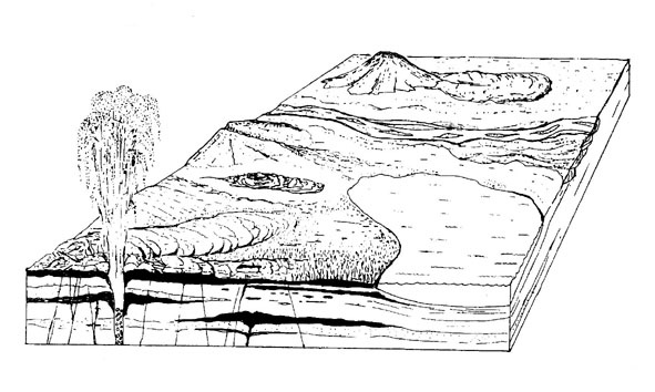
The basin in the south and the northern most region is a half graben, the western edge marked by a low angle (at the current level of erosion) extensional fault system which was active at the time of deposition during the Early Devonian (see below), whereas at the eastern edge of the basin the sediments lay directly on the basement rocks, the contact representing an unconformity. The central to northern area, containing the Rhynie chert locality is now believed to represent a completely fault-bounded strike-slip basin caused by regional trans-tensional forces (Rice and Ashcroft in press). Within the basin the sedimentary rocks are tilted, generally dipping towards the northwest, though the chert-bearing rocks in the area to the northwest of Rhynie village are folded into a syncline, the axis apparently plunging to the northeast.
The cherts are associated with shales and sandstones towards the top of the sedimentary succession and are only known to occur in situ in the vicinity of the village of Rhynie itself, quite close to the faulted western margin of the basin (see inset below). Results from the drilling programmes suggest much of the sedimentary succession here is heavily disrupted by faulting, with the area being divided into a number of small faulted blocks along the main fault zone. The main features including the sedimentology and lithostratigraphy are described below.

- The Boundary Fault
-
- The Basin Fill
-
There is a variety of rock types that comprise the fill of the Rhynie basin including primarily sedimentary rocks (mainly sandstones and shales) and volcanic rocks. Traditionally the sequence of rocks has been divided into three main lithostratigraphic units: the Tillybrachty Sandstone, Quarry Hill Sandstone and Dryden Flags formations; the latter unit in the Rhynie area hosting the cherts (see inset below). See Rice et al. (2002) for details of the stratigraphy. Click on the formation names in the inset below for an outline of the lithologies encountered in each and their inferred environments of deposition.
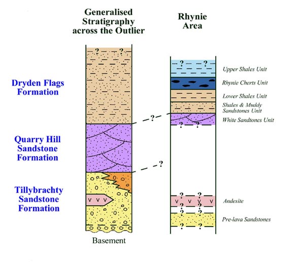
Tillybrachty Sandstone Formation
Quarry Hill Sandstone Formation
Dryden Flags formations
- Basin Evolution
-
The Rhynie basin was formed as a result of trans-tensional forces affecting the Dalradian metamorphic and Ordovician igneous rocks in the northeast Grampian area following the closure of the Iapetus ocean. Based on present knowledge (Rice et al. 2002) the evolution of the Rhynie basin can be described in diagrammatic form.