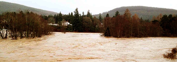
On 30th December 2015, as part of “Storm Frank”, extreme rainfall in the Grampian region drove water-levels along the River Dee to levels not seen since the 1920s. The resultant flooding impacted our communities along the valley. To help us deal with future flood events it would be good to know how the Frank flood-waters built up and then drained away. The Scottish Environment Protection Agency monitor river levels at a few sites along the Dee and its tributaries. We'd like to know what happened between these monitoring stations, especially around narrow-points in the river and its floodplain. These constrictions can act to hold back water, forcing the river to burst its banks, make the water flow faster. Bridges can form these constrictions, and their foundations are threatened by the scouring caused by faster flow.
So we're studying one such location - the Aboyne Bridge that crosses the Dee (on the B968).
What happened at Aboyne Bridge?
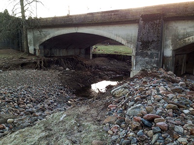
By first light on the 30th December the Dee had already burst its banks and water was flowing not only beneath the main span of Aboyne Bridge but also through the flood arches that connect the bridge to the approach causeway. For the following six hours water-levels rose steadily, reaching the south Deeside road (above the high-risk floodplain as designated by SEPA) by 11.00 am. Water-levels had receded back into main channel of the Dee by the following morning, revealing a floodplain and river that had changed much during the flood. Most obvious was the vast collection of wood (mostly trees) and other debris that was piled up along the river bank and trapped up against other obstructions. But the ground beneath the flood arches at the bridge had been deeply scoured. The extent of this erosion wasn't apparent until Aberdeenshire Council workers pumped out the scour pits. They closed the bridge for emergency repairs (15-20 January 2016). Debris from the scour-pits, boulders and other sediment excavated by the floodwaters were scattered across the field below the bridge.
The photo to the right shows scour damage underneath Aboyne Bridge after the flood
So what do we want to know?
We'd like to understand how the scouring at Aboyne Bridge happened. Were trees important in blocking the flow, increasing turbulence and erosive power of the river? Can we model the flow dynamics?
To do this we need information on the build-up of floodwater and the difference in water-level (“head”) across the bridge and approach causeway. It would be good too to have a record of the flow patterns as charted by waves and stream-lines on the water running across the floodplain. But there are no “official” data.

Schematic diagram of the post 30th December flood with scour pits
under the bridge and sediment deposition downstream, with predicted water flow lines.